
The Wheatbelt Regional NRM Strategy highlights that the majority of the Wheatbelt falls below the target of 30 % native vegetation cover required to maintain an ecologically viable landscape (Table 1).
As part of our commitment to the Regional NRM Strategy, Wheatbelt NRM annually attempts to quantify changes in native vegetation area to track the progress of indicators against the targets laid out in the strategy.
We do this by compiling data from several sources including the area of approved clearing permits supplied by the Department of Water and Environmental Regulation (DWER) to quantify our annual loss of native remnant area.
For example, between 2019 and 2022, 514 ha of native vegetation has been approved for clearance. Fifty percent of this area (257 ha) was approved for the purpose of road construction or maintenance (Figure 1). We know that a great proportion of the remnant vegetation in the Wheatbelt NRM region exists as linear bands in road reserves.
This basic example of natural capital accounting shines a light on an obvious land-use conflict between maintaining road infrastructure and protecting the rare, threatened and dwindling remnant assets that are crucial to maintaining a vibrant, diverse, beautiful and productive Wheatbelt community.
Currently is it very difficult to accurately assess whether as a community we are adequately compensating for the loss of native vegetation through our NRM interventions.
Barriers include:
- Revegetation data is not centralised
- Public datasets such as the CPS are not user friendly making the process of data collation laborious
- Privately funded investments in revegetation are not accounted for
- Remotely sensed estimates of vegetation extent are not produced at a scale useful to accurately detect linear or small, fragmented vegetation patches common to the wheatbelt
Developments in national natural capital accounting and end-user guided plans will hopefully help to overcome the barriers to tracking our progress.
Finally, some food for thought, could autonomous cars play an important role in the future of conservation in the wheatbelt by reducing the need to clear roadside vegetation?
|
Table 1. Summary of the area of remnant bushland by sub-region in the Wheatbelt NRM region |
|
|
Sub-region |
% Remaining Bushland |
|
Avon Arc |
11 |
|
Central Wheatbelt |
6 |
|
Eastern Wheatbelt |
17 |
|
Southern Wheatbelt |
20 |
|
Great Western Woodlands |
99 |
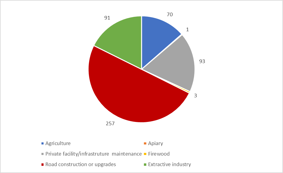
Figure 1. The area of approved clearing permits from 2019-2022 by purpose. Data supplied by the Department of Water and Environmental Regulation (DWER).
Links:
Wheatbelt NRM Inc. Regional NRM Strategy
Department of Water and Environmental Regulation Clearing Permits System
CSIRO Natural capital accounting in Australia’s primary industries.
WABSI Biodiversity Knowledge Priorities
EEA Environmental-Economic Accounting
Published eNews 373, November 2022